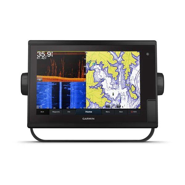
Are you looking for the best chartplotter? If so, you’re in the right place. Being able to find a device that will help you easily navigate the waters while boating is essential.
With today’s current technology it’s never been easier to do some cruising, fishing, or traveling by boat. You can be able to see where you are going and know your current location all on one display. We’ll talk a bit about what a chartplotter is and how it works.
We’ll also show you some of the best chartplotters on the market so you can buy one for yourself. Once you have one installed on your boat, you might not be able to wait until your next boat outing. And we can’t say we blame you.
If you love your boat and want to find a great chartplotter for it, keep reading. Now, let’s dive right into the details.
What is a chartplotter?
Things To Look For In A Chartplotter
Before looking for a chartplotter, it’s important to know what features to look for. Not all chartplotters are created equal. So you’ll want to find one that may be good enough for you in terms of what it includes.
Here are some things to keep a close eye on:
1. Charts/Maps
Without these, the chartplotter would be useless. The only difference between these and road GPS displays is that you will be able to get marine information and details. The displays will mostly use marine terminology like knots.
These will also include depth charts, so you know how deep the water is below the surface. The depth can change just about anywhere depending on the body of water you’re on. On one end of the lake, it can be six feet deep (but at the center, it will be about sixty feet).
Other items included on the map will include points of interest, the shoreline, and your preset routes and paths.
2. Memory Capacity
This is a big one. You’ll want enough memory capacity to store as many set and preset routes as possible. The larger the memory, the better.
3. Screen size
The size of the display screen will determine how easy it will be to read it. How a screen size is measured is from corner to corner (usually diagonally). The bigger the screen, the better it will be to read the data and display information.
4. Connectivity
Most of today’s chartplotters will already have WiFi capabilities built-in. For this reason, you’ll be able to get your readings in real time. Also, you’ll want something that may have bluetooth connectivity as well.
Best Chartplotters
Now, we’ll be taking a look at some of the best chartplotters on the market. While there are a handful of them available, we’ve specifically hand-picked these due to some of the features we’ve liked (and one that might be affordable for you if you’re on a budget). Here’s what they are:
1. Simrad GO7 XSE Chartplotter/Fishfinder
If you are someone who loves to cruise around and maybe catch a few fish out of boredom, the Simrad GO7 XSE just might be what you need. This has a 7 inch display screen that allows you to see what’s in your general vicinity.
What makes this impressive is the Simrad is compatible with almost every chart under the sun. Whether it’s C-MAP or Navionics, it’s probably one of the most compatible chartplotter on the market.
The home screen is easy to customize and navigate with just the touch of your finger.
2. Garmin Echomap Chirp
Garmin is known for making superb GPS equipment. So it comes as no surprise that we throw them in the mix as well. This is a combo chartplotter and fishfinder that comes at a pretty reasonable price. If you’re looking for something that won’t kill your wallet, this might be your best option.
And yes, this too comes with a fishfinder as well. This comes pre-loaded with LakeVU HD maps that will provide you with maps of every lake in the United States and Canada. If you’re more of a deep sea kind of boater, the BlueChart g2 maps will be useful as well (also pre-loaded).
3. Humminbird Helix 5 Marine GPS
Our last chartplotter we’ll be looking at is the Humminbird Helix 5 Marine GPS. It’s accurate, reliable, and yes it’s affordable as well. If the Garmin is a bit out of your price range, then this might be the other viable option.
It has the smallest screen size at five inches. But still, it will allow you to see the display stats on the screen. You’ll know where you are and see what’s in the general vicinity.
This comes with a few preloaded charts, but you can be able to upload some of your own so you have a few designated routes for your favorite lakes, ponds, or even sea routes.
You’ll be able to pick up buoys, hazards, marinas, and so many other navigational items that will help take you from point A to point B.
Final Thoughts
Finding the best chartplotter might be a challenge. But you’ll find one that will give you the most accurate, reliable data possible. Not to mention, it will make navigating the waters a lot easier than it used to be. These three listed above are some of our best options.
But if you find one outside of this list, perfect. At the end of the day, it all comes down to the kind of features you want included and how it will benefit you in the long-term.

